Friday Snow Event
Page created on: 2025-01-08 12:45:04
Analysis of guidance for Friday says it will snow.
The next 2 questions should be how much and when.
I have read consistency in the 2-4" range solution for a few days now and this run is in there again. The timeline solution from multiple sources keeps pushing start time earlier but deeper dive in data still suggests snow will start around sunrise while flurries are possible before.
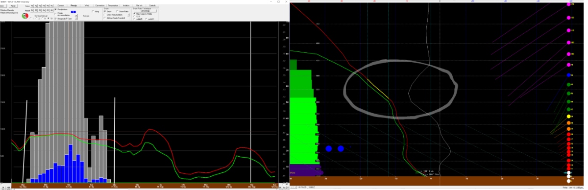
Left chart is timeline with Friday midnight to Saturday midnight bracketed with white vertical lines. Intensity projections are lighter pre-dawn and it is related to projected dry layer at and above the ground that should limit flakes getting to the ground, both size and numbers. We see the drier air in the spread between temperature and dew point (red and green wavy horizontal lines). Sunrise to mid afternoon snow projections appear in every hour so I wanted to find data to refine the detail.
Right panel is noon cross section of atmosphere. Saturated atmosphere appears and stays saturated all the way up to (or below) the snow growth zone. I was most interested in snow growth zone at this time sharing level with some of the best vertical lift and a feeding SW wind. Scenario makes more bigger flakes. Fastest accumulation rates projected just before through just after noon.
Summary: snow flurries early Friday morning with snow showers during the daylight hours, maybe all the daylight hours.
2-4" accumulation (will vary from location to location) lean to the over 2". Heavier totals south of our region.